
Assisting me on this trip will be San Diego based Capt. Brian Ohlfest, who happened to be in St. Maarten looking for a trip back to the states and, for a couple of days, my friend Amber Kandarian, a documentary film maker from Southern California. Below, the crew is enjoying breakfast at "Tickles" in Crown Bay Marina before pushing off for Ponce, Puerto Rico.

25 Feb 2012
We push off for the 10 hour run to Ponce. The owner requested we run at 11 knots at 1250 rpm for economy. The Caterpiller C-32 engine display indicates a fuel burn rate of 32 gallons per hour. The crossing between Vieques and Culebra was uneventful but the wind freshened as we rounded the SE corner of Puerto Rico. Arriving at Ponce Yacht Club at sunset, we tied up for the night at the fuel dock.
26 Feb 2012
We take on 1728 gallons of fuel ($518 savings), confirming the Cat data of 32 gallons per hour. We next push off for the 32 hour run to Puerto Plata, DR. However, as we round Cabo Rojo, the weather forecast for the Mona Passage between Puerto Rico and the Dominican Republic shows freshening winds from E-NE at 20-25 mph and a beam sea of 7-9 feet. With the additional weight of a custom enclosed glass upper skylounge, the boat rolls excessively in a big beam sea. So, caution is the word for the day and we head for Boqueron, a seaside village just around the corner of Cabo Rojo on the southwest coast.

Cabo Rojo Lighthouse

Playa de Boqueron

Amber interviewing Brian

01 March 2012
After 3 days of "wait for weather" we finally get a slight break in the weather and off we go. Sun-upfinds us just north of Cabo Engano on the DR side. The outside temperature is 76 degrees, winds out of the east-northeast at 17 and seas running 7-9 feet off the starboard beam. Mostly northeast swell with small whitecaps on top. Anticipating Ocean World (Puerto Plata) at 2130. Ops normal. Amber had to leave the boat in Boqueron to attend her brother's engagement party in New York, so it's just Brian and I for the rest of the trip.
2130 - Hit the sea buoy exactly at 2130 and dockside at 2145. The entrance to Ocean World at night is pretty simplistic. If you email the marina concierge before your arrival, they will send you a marina map with the Lat/Lon of every single lighted buoy for the entrance. Just look for the yellow lighted sea buoy then, red right returning. Nice big, high concrete docks. A note though... dock as far back in the marina as possible as the front near the entrance has a bit of surge. After tying up, we received a visit from a Dominican Navy officer who stands watch looking for arrivals. Passports and ship's papers in order, not a problem, but make sure you ask for identification before you let anyone onboard after dark. Most times, these officials will be in civilian clothes. The official boarding will be reserved for the morning.

Customs and Immgration arrived promptly during the crew's breakfast. Only two or three forms to sign as they do most of the filling out of the forms. Of course while I am conductiong the interview, another official wants to inspect the rest of the boat. A note of advice here... make sure you brief your crew than no one inspects the cabins below without a crew member present. They will go thru EVERYTHING and vigilance is warranted.
The fuel dock is on the pier with the tower. Diesel here is $6.00 per gallon. After we had fueled and returned to our dock, we were visited by one more official... the country's Drug Police. Once more with the passports and ship's papers and he was on his way. A note on the official entry process... not once did anyone have their hand out for the typical "mordida" that is expected elsewhere, like Samana. The official fees were $65 for entrance, including $10 for each passport stamp (there were two of us.). The salida for the yacht to proceed was an additional $20.


The actual office and reception area for the marina is in the three story building at the head of the fuel dock. The main building at the middle of the marina houses an outstanding pool with swim-up bar and restaurant on the first floor, the Bravissimo floor show is on the second floor, casino is on the third floor and one of the best discotheques on the island is on the fourth. There is even a marine theme park with sea lion and dolphins shows plus swimming with dolphins and nurse sharks. There is something for everyone here.

If you need to replenish the pantry, Tropical Mercado in Puerto Plata provides a courtesy ride into town and back from the marina. The driver, Eddie Rapido is very accommodating and is worthy of a gratuity even though his service is free. Eddie no habla ingles, BTW.

While you are checking in with Luis the dockmaster, check with Victor or Nidia at the concierge desk for specials. Tonight, Brian and I got a two for one voucher for the Bravissimo floor show and 20% off on dinner. Total cost for dinner and show for two was $108 including gratuity. The show is fantastic. Great choreography and energy.


Did I mention how much I love my job?
03 March 2012
We wanted to leave at 0300 to take advantage of the calm in the tropical winds, but the port captain does not allow yachts to leave before 0600. Strange, I know, but I am not going to rock the boat so it's an 0600 departure for Mathewtown on Great Inagua.
04 March 2012
0500: I am up and making breakfast in preparation of a sun-up departure. The wind has shift light to the south and the run up to Cooked Island couldn't be smoother. I had intended on anchoring at Cooked for the night, but when I checked the satellite weather, there is a cold front approaching with severe winds behind it. The office of Bahamas Met is forecasting northeastly winds 20-25 increasing to 25-30 with gale force gusts, so I decide to continue running in calm weather and make Clarence Town on Long Island by 2100 hours.
Mira Por Vos Lighthouse - Western End of Acklins Island

2030: "Show Boat" enters Clarence Town harbor. Special note here folks. Never expect the navigational markers on the chart to actually be there. In this case, only one marker in the channel existed. Having restricted visibility due to tinted bridge windows, I have Brian on the bow calling out breakers on each side of the channel by walkie-talkie.
2100 We grab the last remaining dock available at Flying Fish Marina. Tied to the fuel dock is a 140 foot custom yacht which is doubling lines for the approaching blow and I am comforted that we made the right decision to push thru to Clarence Town.
05 March 2012
After a restful sleep, Brian and I wake up to find a full blown "rage" (that's what the islanders call it). Flags are stiff - the wind is howling in the rigging - palm trees dancing like Tina Turner's hair! Huge waves breaking across the harbor entrance... I am so happy to be here!!! We rig lines bow and stern to hold us off the docks and we settle into a cast away's wait-and-see posture.
Flag pole, Day 1


Flag pole, Day 2

 |
| The alongside depth of the pier is 8' at low tide. Speaking with David Harding, the harbour master yacht are allowed to tie up, but there is no electricity or water. Salt Pond is on the west or lee side of the island. |

Dingy dock just north of the main pier.
Note: Lee side of the island is calm.

At the head of the dingy dock a restaurant pool bar.
The "rage" is full on now and forecasts says end of the week before winds and seas subside. So, Brian and I decide to take in the sights of the island. A sailboat parked next to us told me that the highest gust so far was 42 mph.
Long Island is about 130 kilometers long and 6 km wide at its widest point. The land area is 448 km². Long Island is situated about 265 km southeast of the Bahamian capital of Nassau, which is located on the island of New Providence. The Tropic of Cancer runs through the northern quarter of the island.


A Contemplating Brian

Long Island is particularly noted for its caves, which have played a major role in the island's history. Dean's Blue Hole, located west of Clarence Town, is the world's deepest underwater sinkhole, dropping to a depth of about 200 meters, making it more than double the depth of most other large holes.

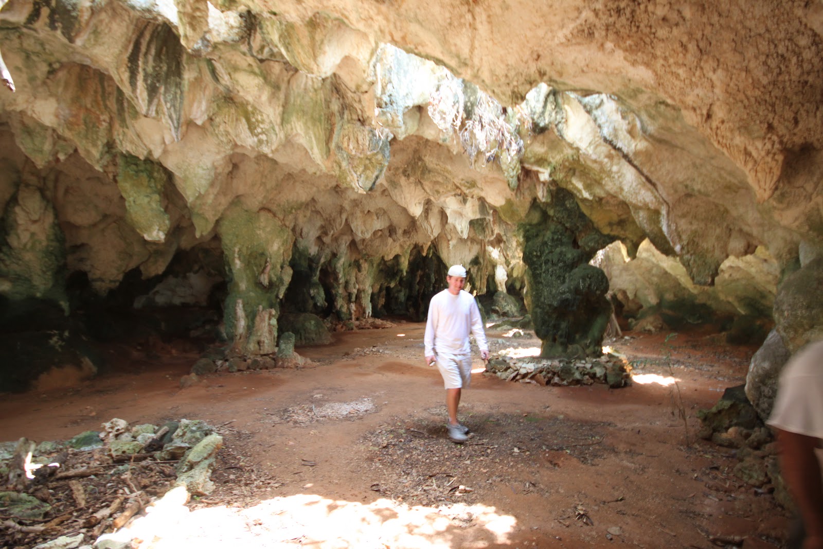
Hamilton Cave Tours is hosted by Leonard Cartwright for $10 per person.
The property which the caves are located have been in the Cartwright familysince the mid 1800s when they bought it from the crown for 27 pounds sterling.


Day three of our weather delay and after taking care of some boat chores in the morning, Brian and I head off the Cape Santa Maria on the north end of Long Island to see what the sea conditions are and to view the Columbus Monument.

Most of the other roads are dirt and crushed limestone in fair condition except those less traveled.

And for those seeking more challenging trails...

On the way to the north end, we picked a random road the see if we could find a route to the east side of the island. What we passed were centurys old plantations overgrown by jungle bordered by hand laid rock walls; one almost hearing the ghosts of plantation slaves past breaking rock to build these borders.

The road wound up paralleling the eastern side of the island and looped back to the highway. However, before we left the inland jungle we came across a blue hole. This was the first blue hole I had seen in the Bahamas which was inland; most I have seen are coastal. But, unlike the cenotes of the Yucatan Peninusla, blue holes here are brackish or saltwater. This blue hole can be viewed on Google Earth at position 23.31.58N by 075.14.13W
After leaving the blue hole, we returned to the Queen's Highway and drove to the end of the road after which we hike up to the monument.


The inscription read:
THIS MONUMENT IS DEDICATED TO THE GENTLE, PEACEFUL AND HAPPY ABORIGINAL PEOPLE OF LONG ISLAND
THE LUCAYANS
AND THE ARRIVAL OF CHRISTOPHER COLUMBUS
ON 17 OCTOBER 1492
Of course what the inscription doesn't read is that the results of the arrival of Chris Columbus signaled the demise of the peaceful and happy aboriginal Lucayans. After a look-see at the raging ocean, Brian and I hiked back down the trail to our rental and headed to Stella Maris Resort for a delicious lunch of grouper fish and chips.

After the sixth night, the winds moderated and the supply boat arrived at Clarence Town. It was time to return the rental and plan our escape from Long Island. Our next stop would be Staniel Cay in the Exumas 100 miles to the north. At 11 knots cruise, this necessitated a dawn departure.
10 March 2012
Alhough the winds had abated, there was still a huge swell running on our beam which made for some interesting moments until the sea swell was broken up by Cat Island off to the east.

WHOA!!!
We arrived at Big Rock Cut, one of the navigable entrances from Exuma Sound onto the Exuma Bank. These passages should always be negotiated when the sun is high and behind you so you can see the rocks and reef that lie beneath. When we arrived at 1630 in the afternoon, the sun was already low in the west which made it difficult to read the water color. However, I have been thru this passage dozens of times and was confident with the entrance. Once inside, a left turn to the south puts the sun over the right shoulder and the colors of the water returns. Hugging the left side of the channel, we pass to the east of what I call Crown Rock and follow the darker blue water to the popular Staniel Cay Yacht Club (www.stanielcay.com). The yacht club has an 18 slip marina, fuel dock (Diesel - $5.89), pastel colored bungalows and the yacht club's world renowned restaurant and bar.

Staniel Cay Yacht Club is owned by David Hocker and it has been in his family for decades. Dinner is served promptly at 1930 and reservations and menu selection are done by VHF or in person ahead of time. Once prepared, the staff rings a ship's bell to signal the pre-assigned seating. During your time waiting to be seated, stroll around the inside of the bar area and see photos of the yacht club in its early days as well as photos from when the James Bond thriller "THUNDERBALL" which was filmed at the grotto which lies a short dingy ride from the yacht club.
 |
David Jackson, bartender |
11 Marh 2012
With over 360 islands, or cays in the Exumas running from north to south, this allows for a calm ride from Staniel Cay to Nassau, 75 miles to the north. So, after Brian cooked breakfast (wink-wink), we headed north with the notion that we were three days from completing this journey.

We arrived at Nassau just after 1700 having made reservations at Nassau Yacht Haven. While Brian was washing down the boat, I made linguini with my delicious bolognaise for dinner.

After dinner, I took my Brian to the world famous Poop Deck Restaurant for my favorite, guava duff, for dessert. It is so good, I ordered two double orders!!

Make sure while you are around the bar area, check out the menus which have been signed by people of notoriety who have dined at this excellent seafood and raw bar.

12 March 2012
Because we arrived after hours, we had to wait until after 0800 for the marina office to open to check-in... and check-out. Once the garbage was disposed of, we repositioned to the Hurricane Hole Fuel Dock, between the two bridges that cross over to Paradise Island, to top up the day tank with diesel ($5.53) and an extra hundred gallons in the forward keel tank for the final push to Fort Lauderdale. There's usually a line-up of boats at the fuel dock, but we were lucky this time to find the fuel dock empty. Before leaving Nassau, we entered the marina at Atlantis and I dropped Brian on the dock with my camera to get some shots of the boat for the owner's charter eBrochure.

The run from Nassau to Fort Lauderdale is just over 160 nautical miles. Leaving Nassau after 1000 would put our arrival at Fort Lauderdale at 0200 in the morning. So, I decided to anchor in the lee of Bimini, approximately 50 miles from Fort Lauderdale, and grab some shut eye until 0700. This would put us in Fort Lauderdale at 1130. So, we arrived at 2230 and dropped the hook in 15 feet of water. The anchorage was a little rolly (like Great Inagua) but we secured the boat and hit our respective bunks. The boat was "sailing around the anchor" pretty good and it made for an uncomfortable anchorage. At 0130, I woke Brian and we weighed anchor. I figured, if you are going to be uncomfortable at anchorage, you might as well be uncomfortable underway.
13 March 2012
With the glow of South Florida in front of us, I settle into the first three hour watch and Brian retired to his stateroom. Seas were off our starboard quarter at what I would guess to be 5-7 feet (which seemed to be the norm on this trip) and the boat was riding well. About half have across though, we were hit be a rouge wave which first dropped the stern of the boat to starboard after which the boat violently rolled to port and broached. I was literally sitting on the arm rest of the helm chair with a kung fu grip counting seconds which felt like minutes ticking by wondering of the boat was coming back. The boat then pointed up towards the north, the autopilot off course alarm yelling W.T.F and then a new alarm I was unfamiliar with, a Heel Fault alarm from the stabilizers!
In the mean time, I am calling down to Brian to see if he is okay instructing him to do an inspection of the boat, because I could swear I saw fishes swimming by the skybridge window! Brian, who is living in the forward VIP cabin came up and told me he was ejected out of the bed and thrown up against the hull before being wedged between the hull and the bed by pillows and bedding. His first thought was, grab the life jacket I had previously hung in his locker.
But below deck the carnage was incredible. Cabinettes popped open ejecting stored items, a couple of drawes in the galley island jumped over their stops and the furnishings in the saloon were in a heap on the port side of the boat. One hears stories of boats being swallowed by the Bermuda Triangle. I have run between Florida and the Bahamas for 25 years without incident, but now I am a believer!!


We got the boat straightened up (pun un-intended) and plodded on to Fort Lauderdale arriving at the breakwater two hours before sunrise. Once inside, I took the boat to an anchorage just north of Las Olas Blvd. bridge and laid down for about an hour. Brian rigged up a hose and gave the boat a freshwater rinse after sunrise before we repositioned the boat to Lauderdale Marina for our official check in by phone wth US Customs and Border Protection. I have a Local Boater Option number which expidites my clearance. Brian, without one, gets the pleasure of appearing in person at Customs at Fort Lauderdale airport after we dock the boat at the owners house.

Happy owners, Bill and Marlene with John Wampler
at their dockside home.
Numbers at a glance:
Total distance: Approximately 1,150 nautical miles
Average speed: 10.8 knots
Total fuel consumed: 2,260 gallons
Average fuel price: $5.25 per gallon
Actual days spent underway: 10
Total days including weather delays (9) and staging for customs/immigration: 21
Number of days given as gratis: 4
Have a delivery or charter that I can assist you with?
Give me a call at 954-646-7656
Email: captwampler@aol.com
See my web site at http://www.yachtaide.com/ for more information